
Lake Turkana is not a destination you can treat casually. At 290 kilometers long and up to 44 kilometers wide, it is the world’s largest permanent desert lake and one of the most geologically extraordinary places on the African continent. Sitting in the Rift Valley at the northern tip of Kenya, it has been continuously inhabited by some of the world’s most distinctive pastoral communities for thousands of years. The landscape along its shores encompasses volcanic islands, ancient lava flows, jade-green water, and windswept plains that look unlike anywhere else in East Africa.
It is also genuinely remote. The road from Nairobi to Loiyangalani, the main access town on the eastern shore, covers around 800 kilometers and takes the better part of two days by vehicle. The commitment required to get there is the same commitment that keeps the lake uncrowded and the experience concentrated. Travelers who plan it carefully will find that Lake Turkana delivers something that no other Kenya destination offers: the sense of arriving somewhere that still requires genuine effort to reach.
This guide covers the practical information travelers need to plan a Lake Turkana trip well.
Understanding the Lake’s Geography
Lake Turkana sits at an elevation of around 360 meters above sea level. The northern end of the lake extends into Ethiopia, where the Omo River feeds roughly 90 percent of the lake’s water volume. The southern end is dry and increasingly so; climate pressures and upstream water management in Ethiopia have reduced lake levels over recent decades, a change visible in the bleached former shorelines above the current water’s edge.
The eastern shore, where most Kenya safari visitors base themselves, is centered on Loiyangalani. This is the most practical access point for camp stays, boat trips onto the lake, and access to nearby communities including El Molo village, one of the smallest ethnic communities in Kenya. The western shore is more remote, accessed from the Turkana town of Kalokol, and is less commonly included in Kenya-based itineraries.
Central Island National Park sits roughly in the middle of the lake and is accessible by boat from Loiyangalani. It holds three crater lakes: Flamingo, Crocodile, and Tilapia. The island is a significant Nile crocodile breeding ground and is estimated to support one of the largest crocodile populations in Africa. South Island National Park, near the southern end of the lake, is another protected area accessible by boat but logistically more complex from Loiyangalani.
Access Options: Road, Fly-in, and Hybrid
Road access from Nairobi via the Isiolo to Marsabit highway and then north toward the lake is the classic route for overland-style itineraries. The Isiolo to Marsabit section is substantially improved tarmac, making the first major section far more manageable than it was a decade ago. Beyond Marsabit, the road quality varies, with the approach to North Horr and the Chalbi Desert crossing requiring serious 4×4 capability and a driver familiar with the terrain.
From Marsabit to Loiyangalani is approximately 270 kilometers and takes five to eight hours depending on conditions and the section of the Chalbi crossed. Total drive time from Nairobi to Loiyangalani, staged over two days, is realistic and gives travelers meaningful ground-level context before arrival at the lake.
Fly-in access via light aircraft has improved significantly in the past several years. Loiyangalani has an airstrip that handles Cessna Caravans and similar light aircraft. The flight from Wilson Airport in Nairobi takes approximately one hour and forty-five minutes, transforming what is a multi-day road journey into a single morning segment. Flight operations here are weather-dependent; strong afternoon winds off the lake and across the Turkana corridor are common, and departures are often best scheduled in the morning.
Hybrid access is the format most consistently used by first-time Lake Turkana visitors on itineraries of ten days or fewer. The most common version is flying in to Loiyangalani and driving out via Marsabit and the Samburu corridor, or the reverse. This gives overland texture in one direction while protecting total itinerary time.
The detailed comparison between fly-in and overland formats across northern Kenya is covered in the Tourinsights fly-in vs overland northern Kenya guide, which addresses cost and time trade-offs for each option.
Where to Base
Loiyangalani is the primary base for eastern shore visits. It has the highest concentration of accommodation options, from comfortable tented camps at the upper end to simpler guest facilities at the other. Access to boat trips, community visits, and game drives in the surrounding area all run most practically from a Loiyangalani base.
The surrounding territory offers different environments at short range. The Matthews Range lies to the south, accessible as a detour. The Huri Hills sit to the east, with routes used by Gabbra and Borana pastoralists crossing into the territory between the lake and the Chalbi. A good camp placement in Loiyangalani gives travelers access to lake activities, vehicle-based exploration of the semi-arid hinterland, and community interaction opportunities without requiring significant additional transfers.
For travelers building longer itineraries with deeper northern ambitions, some operators position mobile camps further along the lake corridor, including toward Koobi Fora on the eastern shore north of Alia Bay. This area is archaeologically significant: the Koobi Fora research station has been a major site for paleoanthropological work since the 1960s and holds one of the richest concentrations of early human fossil material anywhere on Earth. Access to Koobi Fora requires advance arrangement and is best suited to travelers with a specific interest in the site.
Best Months for Lake Turkana
The lake itself is accessible year-round in the sense that it does not close or go out of season. What changes with month is the condition of the access routes and the comfort of the stay.
January to March is the most reliable window for road access. Dry conditions hold across the northern circuit, the Chalbi crossing is at its most predictable, and heat on the lake shore is manageable with proper preparation. February is often the strongest month for photography, with long clear-sky windows and good morning light.
June to October is the preferred planning window for most travelers on northern circuits. The second dry season keeps roads open and conditions consistent. June and September are often less crowded than July and August while delivering very similar conditions.
November to early December can work with a more conservative approach. The short rains can affect road conditions on some Marsabit approaches, but the lake itself is undisturbed and camp conditions remain good. Value pricing is common in this window.
April to May requires genuine flexibility. The long rains can render sections of the Chalbi and northern approach roads difficult or temporarily impassable. Travelers who want the lake experience in this period should fly in rather than drive, and should carry buffer days for possible weather disruptions.
Wind is a consistent feature at Loiyangalani regardless of season, driven by the lake’s position in the Rift Valley funnel. Afternoon winds are often strong and dusty. Travelers who plan boat trips should schedule them for morning and stay flexible on afternoon lake activity timing.
Camp and Logistics Priorities
At Lake Turkana, logistics quality defines comfort in a way that camp room category cannot. The most important operational factors are:
Water reliability: the lake water itself is not potable, and camp water supply depends on either trucking or treatment from local bore sources. Good camps have reliable supply systems; weaker operations show up in this area first.
Power availability: consistent power for charging camera batteries, satellite phones, and personal devices requires either a well-maintained generator or sufficient solar capacity. Ask specifically about power availability hours when comparing camps.
Communication: satellite communication coverage at Loiyangalani is reasonable for the northern circuit. Safaricom signal exists in town but degrades quickly outside the main settlement area. Camps with their own communication capability provide significantly better safety margins.
Fuel and resupply: Loiyangalani has fuel, but supply can be intermittent. Travelers moving beyond Loiyangalani in either direction should confirm fuel availability with their operator before departure.
Vehicle support: for any movement beyond the immediate Loiyangalani area, a recovery-capable 4×4 with a driver who knows the specific terrain is the baseline. The road north toward Alia Bay and the routes across the Chalbi to Marsabit are not terrain for unprepared vehicles.
Cultural and Landscape Highlights
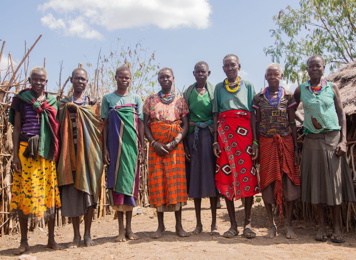
The human geography of the Lake Turkana shore is as interesting as its physical landscape. Several distinct communities live along and near the eastern shore, each with specific relationships to the lake, the land, and each other.
El Molo community near Loiyangalani is one of the smallest ethnic groups in Kenya, traditionally dependent on fishing, crocodile hunting, and hippopotamus hunting in the lake. The community has undergone significant change over the past generation, with intermarriage with neighboring Turkana and Samburu groups and a shift toward more diversified livelihoods. A respectful visit to the El Molo village, ideally coordinated through a camp or community liaison rather than arrived at independently, provides insight into a culture that has adapted to one of Africa’s harshest living environments with remarkable creativity.
Turkana pastoralists move through the western and northern lake shore areas with cattle and camels. Their material culture, including the elaborate beadwork and hairstyling of younger men, is distinctive and visually striking. Interaction opportunities depend on who is in the area at the time of your visit, making flexibility on this front more practical than advance scheduling.
Sibiloi National Park and Koobi Fora to the north of Alia Bay are accessible by charter flight or boat and represent one of the world’s most significant paleoanthropological sites. Fossils of Homo habilis, Homo erectus, and Paranthropus boisei have all been recovered here. The Kenya National Museum manages a research and interpretation facility at Koobi Fora. Travelers with interest in human origins find this context changes the entire experience of standing on the lake shore.
Central Island is accessible by motorized boat from Loiyangalani in roughly an hour. The island’s three crater lakes hold different populations of flamingo, tilapia, and Nile crocodile. The crocodile population is especially visible during breeding season. The island’s summit viewpoints provide a lake panorama that no shore-based position can replicate.
A Sample 6-Day Lake Turkana Framework
This itinerary works for fly-in entry and overland exit via Marsabit, covering the lake and the Chalbi corridor.
Day 1: Fly from Wilson Airport to Loiyangalani. Afternoon orientation drive in the semi-arid hinterland east of the lake. Camp arrival for sunset on the shore.
Day 2: Morning boat trip to Central Island, timing departure before wind builds. Crocodile colony and crater lake observation. Return for midday rest. Afternoon El Molo community visit.
Day 3: Full day along the lake shore. Option to extend north by vehicle for photography and landscape work in the volcanic terrain north of Loiyangalani. This day holds buffer capacity for weather or boat condition adjustments.
Day 4: Depart Loiyangalani toward North Horr via the Chalbi Desert segment. Arrive North Horr for overnight, using local guest facilities. Orientation drive across the Chalbi salt pan in evening light.
Day 5: North Horr to Marsabit via the eastern Chalbi approach. Arrive Marsabit for overnight. Afternoon walk in Marsabit forest or crater lake area.
Day 6: Marsabit to Samburu via the Isiolo highway, or continue south depending on broader itinerary.
With genuine buffer built into Day 3 and flexibility on the Chalbi crossing timing on Day 4, this framework handles most condition variability without forcing rushed decisions.
Practical Notes
Six to eight days is the minimum allocation for a Lake Turkana trip that includes meaningful time at the lake, proper transit pacing, and at least one full rest buffer. Travelers who try to compress Nairobi-Turkana-back into four or five days consistently report that they spent too much time in transit to experience the destination properly.
Heat management is a real consideration. Loiyangalani sits in an arid zone and midday temperatures regularly reach 35 to 38 degrees Celsius. Activities that work best early morning and late afternoon, with genuine rest in the midday period, produce a much more comfortable experience than trying to maintain full-day activity intensity.
Private departures, where the vehicle and camp space are not shared with other travelers, are the norm for Lake Turkana rather than the exception. Group departures exist but are rare. Traveling with a dedicated vehicle and guide is not a premium option here; it is the practical standard for managing the logistics flexibly enough to handle what the terrain and weather require.
Conclusion
Lake Turkana rewards travelers who invest in planning it properly. The access is demanding, the logistics require attention, and the experience is unlike anything else in Kenya’s safari circuit. The lake’s combination of ancient geology, extraordinary wildlife in the form of the Nile crocodile population, distinctive cultural communities, and sheer visual drama at the water’s edge produces a trip that most travelers describe as permanently memorable. The effort to get there is part of what makes the destination feel earned.
Reader Next Steps
Travelers building a northern Kenya circuit that includes Lake Turkana will find the Tourinsights Chalbi Desert safari guide essential for the desert crossing segment. The Marsabit National Park guide covers the highland approach in detail. For transport format planning, see the fly-in vs overland northern Kenya comparison. For supported northern circuit planning with Lake Turkana included, Trunktrails Safaris runs dedicated itineraries to this region.